Crappy Weather to Start Work Week
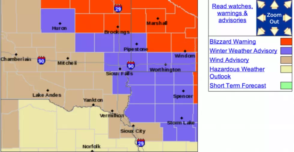
It looks like it could be a bumpy start to the work week in South Easter South Dakota, South Western Minnesota, & North Western Iowa. You will definitely want to monitor the weather conditions before you send the kids off to school. Please, check back here in the morning for school late starts and cancelations. Here is the latest from the NWS in Sioux Falls:
...WINTER WEATHER ADVISORY REMAINS IN EFFECT FROM 7 PM THIS
EVENING TO 7 PM CDT MONDAY...

* TIMING...RAIN SHOWERS IN SOUTH CENTRAL SOUTH DAKOTA LATE THIS
  AFTERNOON...WILL EXPAND IN COVERAGE AND CHANGE TO SNOW AS THE
  PRECIPITATION SPREADS EAST ACROSS THE REGION THIS EVENING. SNOW
  WILL THEN CONTINUE INTO MONDAY MORNING...WITH SNOWFALL POSSIBLY
  BECOMING HEAVY AT TIMES. STRONG NORTHWEST WINDS WILL DEVELOP LATE
  TONIGHT...CAUSING AREAS OF BLOWING SNOW THROUGHOUT THE DAY MONDAY

* ACCUMULATIONS...1 TO 3 INCHES OF SNOW ARE LIKELY TONIGHT...WITH
  THE HIGHEST ACCUMULATIONS EXPECTED EAST OF HIWY 75 IN NORTHWEST
  IOWA AND SOUTHWEST MINNESOTA. ADDITIONAL LIGHT ACCUMULATIONS LESS
  THAN A HALF INCH ARE POSSIBLE WITH SCATTERED SNOW SHOWERS MONDAY.

* WIND AND VISIBILITY...NORTHWEST WINDS OF 25 TO 35 MPH WITH GUSTS TO 45 MPH WILL DEVELOP BY EARLY MONDAY MORNING. THIS WILL RESULT IN
  OCCASIONAL VISIBILITY BELOW A HALF MILE AT TIMES ON MONDAY...DUE TO AREAS OF BLOWING SNOW. EVEN THOUGH THE SOUTHERLY WINDS WONT BE  AS STRONG TONIGHT...THERE COULD BE PERIODS OF REDUCED VISIBILITIES AS THE SNOW IS FALLING.
7-DAY FORECAST
- Tonight-Occasional rain and snow showers, becoming all snow after 2am, then gradually ending. Low around 22. Breezy, with a south southeast wind 15 to 25 mph becoming west southwest after midnight. Winds could gust as high as 35 mph. Chance of precipitation is 90%. Total nighttime snow accumulation of around an inch possible.
- Monday-Areas of blowing snow and a slight chance of snow showers after 8am. Mostly cloudy, with a temperature falling to around 22 by 11am. Windy, with a west northwest wind 20 to 30 mph, with gusts as high as 40 mph. Chance of precipitation is 20%.
- Monday Night-Partly cloudy, with a low around 7. Blustery, with a northwest wind 15 to 25 mph decreasing to 5 to 15 mph after midnight. Winds could gust as high as 30 mph.
- Tuesday-Scattered flurries between 8am and 2pm. Partly sunny, with a high near 32. Light north northwest wind becoming northwest 10 to 15 mph in the afternoon.
- Tuesday Night-Mostly cloudy, then gradually becoming mostly clear, with a low around 9. North northwest wind 10 to 15 mph.
- Wednesday-Sunny, with a high near 27.
More From KKRC-FM / 97.3 KKRC