Winter Storm Warning For Wednesday
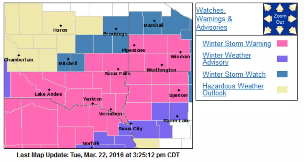
The National Weather Service has issued a Winter Storm Warning for Wednesday March 23, 2016. The Watch area includes southeastern South Dakota, northern Iowa and southern Minnesota. Including the city of Sioux Falls. Six to eight inches of snow and strong winds are possible.
From the National Weather Service in Sioux Falls:
Here's the latest on the upcoming snow chances for Wednesday and Wednesday night. Some things to remember:
1.) There may be a more localized heavier snow band.
2.) We can't rule out isolated thunder with the snow.
3.) Warmer temperatures could impact snow totals for some.
4.) Strong winds with gusts to 45 mph will lead to poor driving conditions late Wednesday into Wednesday night.
This forecast will continue to evolve as some uncertainties in the forecast persist. Be sure to check the forecast BEFORE you leave in the morning.
THE NATIONAL WEATHER SERVICE IN SIOUX FALLS HAS ISSUED A WINTER
STORM WARNING FOR SNOW AND BLOWING SNOW...WHICH IS IN EFFECT FROM
10 AM WEDNESDAY TO 1 AM CDT THURSDAY. THE WINTER STORM WATCH IS NO
LONGER IN EFFECT.

* TIMING...RAIN WILL GRADUALLY TRANSITION TO SNOW LATE WEDNESDAY
  MORNING. MODERATE TO HEAVY SNOW WILL BE POSSIBLE WEDNESDAY
  AFTERNOON AND EVENING.

* ACCUMULATIONS...4 TO 8 INCHES OF SNOW WITH ISOLATED HIGHER
  AMOUNTS POSSIBLE.

* WIND AND VISIBILITY...STRONG NORTH TO NORTHEAST WINDS BETWEEN
  25 AND 35 MPH GUSTING AS HIGH AS 45 MPH WILL BE POSSIBLE
  WEDNESDAY WITH WINDS DECREASING WEDNESDAY EVENING. VISIBILITY
  IN FALLING AND BLOWING SNOW MAY BE REDUCED TO UNDER A QUARTER
  MILE AT TIMES.

* IMPACTS...FALLING SNOW AND BLOWING SNOW WILL LEAD TO DIFFICULT
  TRAVEL CONDITIONS WEDNESDAY AFTERNOON AND CONTINUING  INTO
  WEDNESDAY NIGHT.


PRECAUTIONARY/PREPAREDNESS ACTIONS...

A WINTER STORM WATCH MEANS THERE IS A POTENTIAL FOR SIGNIFICANT
SNOW...SLEET...ICE ACCUMULATIONS...AND BLOWING SNOW THAT MAY
IMPACT TRAVEL. CONTINUE TO MONITOR THE LATEST FORECASTS.
See Also:
More From KKRC-FM / 97.3 KKRC